|
Big Salmon Habitat Project Begins on Nooksack River Tribes Arrange Construction of River Logjams 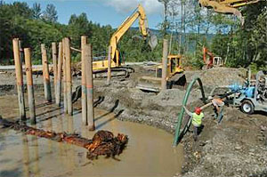 Workers from
Lummi Natural Resources and The project, coordinated by the Lummi and Nooksack tribes' natural resources departments, is intended to help restore dwindling stocks of spring Chinook salmon and bull trout. It will provide cover from predators and deep pools of cool water where the fish can rest on their way to their spawning grounds. Both fish are listed as threatened under the federal Endangered Species Act. Only 120 wild salmon returned to the south fork to spawn in 2005, according to Nooksack Natural Resources. A count of bull trout was unavailable. The project is expected to cost more than $1 million, paid for by federal salmon recovery grants. New Direction A few months ago, a trail led through trees to the bank where Hutchinson Creek flowed gently along the back of a 700-foot berm of dirt and rock and joined the south fork of the Nooksack in an arrangement that resembled a freeway onramp. By Wednesday, workers had removed about half of the dike that separated the creek from the river and redirected the creek. The trees had been cleared, and clusters of pilings stuck up out of the soft dirt and gravel. Bob Doucette, who with his wife owns Gooseberry Point-based Do Construction, swung the arm of an excavator around and clamped the thumb down on a 60-foot cedar tree, its mess of roots still attached. He lifted the tree, laced it through the pilings and dropped it in a pool of water with an impressive splash. Doucette, a former fisherman, could visualize how the project would improve habitat for fish. "It will have deep holes and a settled area to rest up before they hit the spawning grounds," he said. "I would like to see (strong fish runs) come back." The Details The logjams involve pilings driven 40 feet underground, and logs buried about 20 feet deep, leaving about 10 feet visible above the surface, said Mike Maudlin, a geologist for Lummi Natural Resources. In addition to the logjams and the dike that was removed, the project involves building a 460-foot-long rock wall about 2,000 feet to the north. The wall is intended as a backstop in case of floods. It should act as a plug, preventing water from reclaiming an ancient river channel and damaging nearby private property. "But it's designed so the river won't get that far," Maudlin said. That is, if the river's current configuration remains the same, he said. If an upstream levee fails, it could make the backstop a critical barrier. As added protection, the county plans to build a 600-foot extension to the plug. When the project is completed, workers will remove the remaining rocks that are keeping the muddy work site separate from the river. The south fork should sweep into the cleared area and wash through the logjams. Hutchinson Creek will be released from its diverted path to join the south fork. In the winter, the fast moving south fork water will scour out the pools, and in the summer, the creek, which is a good 20 degrees cooler than the south fork, should chill the pools, making it more pleasant for fish. Reach Katie N. Johannes at
katie.johannes@bellinghamherald.com or
call 756-2805. |
||||||||||||||||||||