|
 |

Salmon and the Green/Duwamish Watershed
| |
For
more information about salmon recovery planning
in this watershed, click here.
Click here to read
this watershed's feedback summary.
|
 |
 |
|
|
|
Key
Facts |
| |
Year 2000 population estimate is
583,692; 89% reside within the Urban Growth Area designated
under the state Growth Management Act.
Projected population growth is 16% from 2000 to 2020;
the fastest growth is expected in suburban cities and
unincorporated areas south and southwest of Seattle.
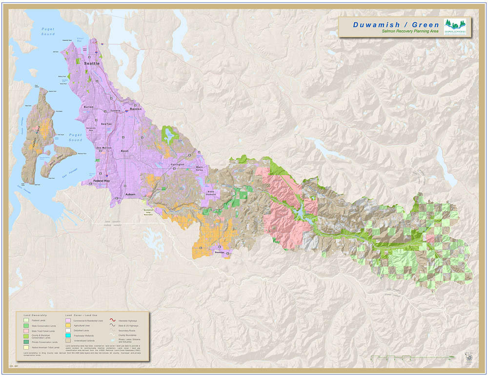
Located entirely in King County, the watershed is
home to 15 other jurisdictions, including the cities
of Seattle, Renton, Kent, Auburn, SeaTac, Federal Way,
Tukwila, Burien, Covington, Maple Valley and Enumclaw.
The watershed also is the City of Tacoma’s water
supply and is becoming interconnected with the regional
water supply grid.
The planning area for the watershed under the state
Watershed Management Act is all of Watershed Resource
Inventory Area (WRIA) 9, and portions of WRIAs 8, 10,
and 15.
|
|
| |
|
This watershed starts high in the Cascade mountain range at the
headwaters of the Green River. The upper third of the Green flows
through forest land. After about thirty miles, it begins to meander
through agricultural lands, small woodland lots, state and county
parks, and small towns that rapidly become busy Seattle suburbs.
The lands surrounding the river become more urban and more industrialized
as we follow it downstream. The Green flows into the Duwamish River
eleven miles from its mouth flanked by landscape that shifts from
suburban to industrial as it approaches the waterways at the delta,
where sports stadiums built on the former mudflat and giant shipping
cranes welcome the Duwamish as it flows into Elliott Bay.
The Green/Duwamish and Central Puget Sound Watershed has 92 miles
of marine shoreline, anchored by Elliott Bay to the north and Dumas
Bay to the south on the mainland, and the shores of Vashon and Maury
Islands.
Located at the downstream end of the Green River gorge, Flaming
Geyser State Park is a popular take out point for rafters and kayakers
enjoying whitewater adventures in the gorge. The park's namesake,
the Flaming geyser, and its smaller companion, the Bubbling geyser
are both unique and intriguing features. While only burning 6 to
10 inches high now, in its younger days it burned several feet high
with gushes of fire and water. It was even featured on Ripley's Believe
It or Not.
The Green River is usually one of the top ten steelhead rivers in
Washington. It is also a top white water rafting river, containing
Class IV and V rapids in the scenic Green River Gorge.
The Duwamish River, a key passage to the inland portions of the
state, was a prime focus of heavy industrial development over the
last century. The lower river’s meandering course through 9
miles of wetlands, tidal marshes and intertidal mudflats was straightened
(channelized) and dredged down to 5 miles between 1900 and 1940 to
provide shipping lanes and new land for Seattle’s burgeoning
industrial and manufacturing district. Indeed the Duwamish embodies
all the challenges facing Puget Sound salmon – growth pressures,
shoreline alterations, combined sewer overflow, stormwater run-off,
contaminated sediment, urbanization, industrial development and up-river
habitat passage barriers and degradation from dams, agriculture and
forestry. The Duwamish remains a river of major cultural importance
to Native Americans.
Despite enduring tumultuous change in a short period of time the
Duwamish and its sole remaining tributary, the Green River, still
support substantial populations of naturally spawning and hatchery
salmon as well as a heron rookery. The Green’s Bass Lake/wetland
complex has the greatest bird species diversity of wetlands surveyed
in King County. Local, state, federal and tribal governments, area
businesses and environmental stewardship groups have demonstrated
a sustained commitment to protect and restore salmon and the health
of the watershed.
Major Policy or Actions Needed
to Recover Salmon
Since the late 1980s, half-a-dozen major collaborations have taken aim at restoring
the Duwamish watershed, including the Lower Duwamish Superfund and Elliott Bay/Duwamish
Restoration Program. Current collaborative restoration and protection efforts
involve state, federal and local governments, including King County, Tacoma,
and all 15 cities in the watersheds. Boeing and other area businesses and environmental
groups also participate. Current goals to address habitat issues in support of
salmon conservation and recovery are:
- Protect currently functioning habitat primarily in the Middle
Green River and the nearshore areas of Vashon/Maury Island.
- Connect the Upper Green River by restoring fish passage at Howard
Hanson Dam.
- Ensure adequate juvenile salmon survival in the Lower Green River,
Duwamish Estuary, and other nearshore areas.
Howard Hanson Dam completely blocks passage of adult salmon and cuts off access
to 45 percent of the stream miles historically available to migrating fish.
The Army Corps of Engineers (Corps) and the City of Tacoma are working to restore
access, which is expected to significantly open up the amount of available
habitat for returning adult salmon and their offspring.
Tacoma Public Utilities and the U.S. Corps of Engineers and other partners
are sharing costs for developing the Additional Water Storage Project. The
project will make more municipal water available for fast-growing cities in
south King County and allow Howard Hanson Dam managers to improve flows for
fish in the Middle and Lower Green River.
| We’re
Making Progress—Some Accomplishments |
Strategic Habitat Restoration
Over 500 acres have been acquired by local governments for habitat protection
and restoration purposes in the watershed since 1999. Most of this high quality
habitat is in the Middle Green, a part of the watershed identified as essential
to protect threatened Chinook. A portion of the 500 acres slated for restoration
are in the Duwamish and will provide scarce rearing habitat for estuary-dependent
juvenile Chinook. A multiple-year partnership among the local governments
and the U.S. Army Corps of Engineers is in the $113 million construction
phase. 45 major habitat restoration projects will be constructed over 20
years.
Successful Growth Management
Since the inception of the Growth Management Act, the dramatic increase in residential
development in designated Urban Growth Areas within the watershed has been
accompanied by decreases in residential development in rural and forest areas.
Flood Control and Habitat Improvements in
the Floodplain
The Green River Flood Control Zone District routinely includes habitat improvements
as part of flood facility repair and reconstruction. This includes placement
of large woody debris, levee setbacks, and planting native riparian vegetation
along the mainstem of the Lower Green River. King County’s Flood Hazard
Reduction Plan is being updated to ensure compliance with Endangered Species
Act mandates. |
|
Back to Top | Back
to Watershed Profiles
|