|

Salmon and the Nisqually Watershed
| |
For
more information about salmon recovery planning in this
watershed, click here.
Click here to read
this watershed's feedback summary.
|
 |
 |
|
|
|
Key
Facts |
| |
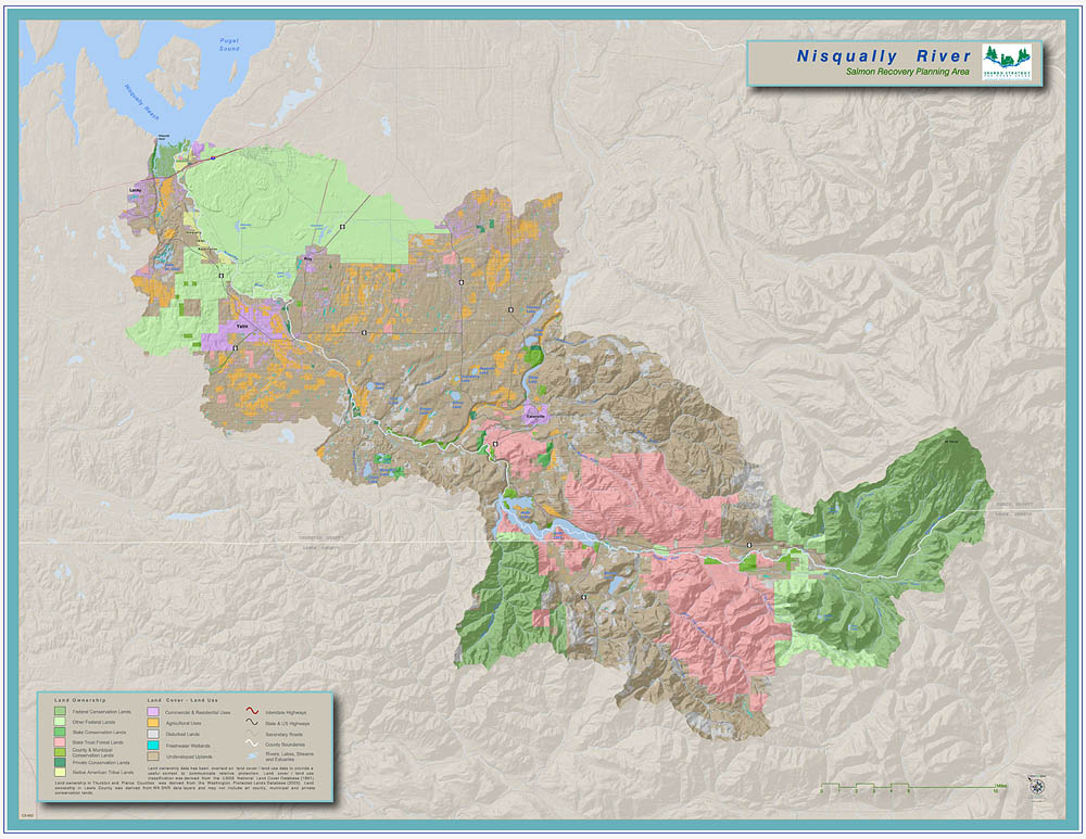
| Land use and ownership patterns
in the upper watershed is 78% forestry and recreation,
18% national park lands, 2% agriculture and 2% urban. In
the lower watershed 22% forestry, 18% forest/prairie (military-owned),
4% agriculture, 49% rural/residential, 3% residential,
2% urban.
Located in Thurston, Pierce and Lewis counties,
cities in the watershed include Eatonville, Roy and
Yelm.
The planning area for the watershed under the state
Watershed Management Act is Watershed Resource Inventory
Area (WRIA) 11. |
|
| |
|
On a clear day the banks of the Nisqually River near the shore
of Southern Puget Sound offer a stunning view of the river’s
birth waters more than 70 miles away. The river begins at the Nisqually
Glacier on the southwest flank of Mt. Rainier, the largest and
best-known of 13 volcanoes spanning the Cascade Mountains of Oregon
and Washington. The river carves a path through rugged Mt. Rainier
National Park, forest and prairies lands before reaching rural
lowlands and a broad delta punctuated by the 3000-acre Nisqually
National Wildlife Refuge.
The Nisqually watershed supports one threatened Chinook population
and numerous other species of salmon, including a unique late-timed
population of chum. The Nisqually is nationally-recognized for years
of success in protecting salmon and watershed health. The Nisqually
Tribe has pioneered agreements among local, state and Tribal governments,
area businesses and land owners to sustain the natural bounty of
the river and the local economy.
Much of the credit for successful collaboration is given to Billy
Frank, Jr., a beloved tribal leader. People who started out questioning
salmon conservation efforts say that Billy Frank Jr. was a calming
influence because he kept saying that he wanted solutions that allowed
farming, forestry and fish to thrive.
In a Trust for Public Land study released in 2001, the Nisqually
river basin was listed among the ten most important rivers in Puget
Sound for salmon recovery. This is in part due to the fact that the
lower portion of the river is considered among the best remaining
intact salmon habitat. Between river miles (RM) 4.5 and 12.7, the
river meanders freely across the valley floor; large woody debris
is present in large amounts, and there is a healthy riparian zone.
The Nisqually River also has the largest undeveloped delta in Puget
Sound.
Major Policy or
Actions Needed to Recover Salmon
Protecting existing conditions is a high priority for salmon recovery
planners in the Nisqually river basin. The Nisqually Recovery Team
set a goal to protect 90% of 84 miles of mainstem core habitat. 68%
is already in protected status. The remaining 22% will be reached
by building on the record of successful agreements among diverse
stakeholders. Current collaborative land acquisition efforts by the
Nisqually Recovery Team involve the Nisqually Basin Land Trust, Cities
of Centralia and Tacoma and Fort Lewis.
Key actions to protect and restore estuary habitat have been identified
as part of a comprehensive plan to restore robust estuary functions.
Actions such as the return of Braget family farm lands to tide
flat are the result of many years of trust building and collaboration
among the Nisqually Tribe, salmon recovery advocates and agricultural
interests. Looking ahead, planning goals include returning both
Tribal-owned estuary lands and estuary portions of the Nisqually
National Wildlife Refuge to a healthy functioning condition. The
plan also calls for a study of the impact of Interstate 5 and ways
to mitigate that impact.
The Nisqually Chinook Recovery Team’s action plan includes
harvest and hatchery management measures. To ensure a sustainable
harvest that also meets harvest goals for treaty and non-treaty fisheries,
the goal is to allow enough Chinook to escape harvest that 1,100
Chinook will spawn naturally in the river. Additionally, guidelines
have been developed for operating hatcheries to minimize negative
impacts of hatchery fish on natural spawners.
| We’re
Making Progress—Some Accomplishments |
Key Land Acquisition
The Nisqually Tribe acquired 410 acres of the Braget family
farm, most in the lowlands and estuary of the Nisqually
will result in restoration of all diked habitat on
the farm. More than 30 acres of the farm were restored
as tidal habitat when a dike was breached in November
2002.
Estuary Restoration
The U.S. Fish and Wildlife Service has proposed restoring
700 acres of estuary in the Nisqually National Wildlife
Refuge to a naturally functioning condition. The proposal
is part of the agency’s preferred option in a draft
management plan for the refuge which could be adopted as
early as 2005.
|
|
Organizations Involved
- Lewis County
- Pierce County
- Thurston County
- WA Dept. of Fish & Wildlife
- WA Parks & Rec Commission
- WA Dept. of Natural Resources
- Nisqually Tribe
- Citizen's Advisory Committee Rep
- WA Dept. of Ecology
- WA Conservation Commission
- UW Pack Forest
- US Army at Fort Lewis
- Nisqually Natl Wildlife Refuge
- Mt. Rainier National Park
- Tacoma Public Utilities
- Municipalities Joint Rep - Eatonville, Roy, Yelm
- Gifford Pinchot Natl Forest
- Citizen's Advisory Committee Reps
Back to Top | Back
to Watershed Profiles
|