|

Salmon and the Stillaguamish River
| |
For
more information about salmon recovery planning in this
watershed, click here.
Click here to read this watershed's feedback summary.
|
 |
 |
|
|
|
Key
Facts |
| |
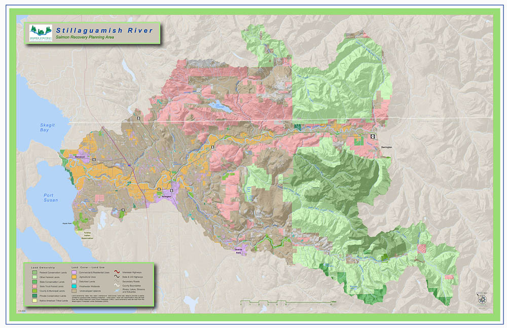
Land use in the portion
of the watershed inhabited by salmon is 61 % forestry,
22% rural residential, 15 % agricultural and 2 % urban.
Spanning northern Snohomish and southern Skagit counties,
major cities within the watershed include Arlington,
Darrington, Granite Falls and Stanwood.
Major public
landholdings are managed by the U.S. Forest Service
Mt. Baker-Snoqualmie National Forest, Washington State
Department of Natural Resources and Snohomish County.
The
planning area for the watershed under the state Watershed
Management Act is Watershed Resource Inventory Area
(WRIA) 5.
|
|
| |
|
The Stillaguamish Watershed drains about 700 square miles of Snohomish
and Skagit Counties. The mainstem Stillaguamish River is formed by
the North and South Forks, which descend from the foothills of the
Cascades to a confluence at Arlington and flow westerly into Port
Susan and South Skagit Bay.
Staples of the early Western Washington economy, forestry and farming
are still major players in the Stillaguamish watershed, where steep,
but lush forest slopes and a broad soil-rich delta provide ideal
growing conditions. A unique characteristic of the Stillaguamish
basin is its low level of commercial development along the I-5 corridor.
It is one of the few, largely undeveloped rural areas adjacent to
major urban centers in Puget Sound. Residents in the basin feel a
strong sense of community and pride in their area. Its rural nature
provides a significant opportunity to protect key salmon habitat
and restore or enhance properly functioning conditions.
The Stillaguamish watershed is home to an early collaborative effort
to address watershed health. Local stakeholders, including Snohomish
County, the Tulalip and Stillaguamish Tribes, farmers, forest land
owners, citizens and local agency representatives committed in 1990
to take actions to improve water quality. Recently, the Stillaguamish
Implementation Review Committee (SIRC) has since turned its attention
to salmon habitat protection and recovery with a focus on chinook
salmon. The Stillaguamish supports two of Puget Sound’s twenty-two
threatened populations of chinook salmon.
Major Policy or Actions Needed to Recover Salmon
A major priority in the basin is protecting and restoring estuary,
nearshore and floodplain habitat. The watershed is poised to make
significant progress on this priority in the next 5 to10 years.
Farmers have already restored access to some tidal channels. For
two years, the Stillaguamish Flood Control District, in conjunction
with the Stillaguamish Tribe, has been diligently experimenting
with new, lighter tide gates and refining how the gates can work
for both fish and farmers. The District has constructed over eighty
of these improved gates to date.
The District also partnered with the Tribe to restore riparian
function and instream water quality along 8 miles of the Old Stillaguamish
Channel. Incentives are needed for farmers and other land owners
to restore access to side channels in the estuary and along the
mainstem of the river. A comprehensive effort is needed to both provide
flood storage and floodplain connectivity for habitat.
Recent changes to the Washington State forest practice rules as a
result of the Forests and Fish agreement are encouraging. The
Agreement lays out ways to balance forest harvest, forest road building and
forest practice activities on steep slopes and riparian areas
with the need to consider the effects on salmon habitat. The SIRC has
identified additional issues to discuss with forest landowners
in the watershed including: limits on cumulative areas of clear cutting
within certain timeframes, and the amount of immature forest
in the basin at any one time. New forest practices will need to be funded,
implemented and monitored if the changes are to be effective.
Voluntary habitat restoration will not be effective without adequate
enforcement of local, state and federal land use regulations. Lack
of enforcement staff and funding contributes to current poor habitat
conditions. Existing zoning, critical areas and other development
regulations should be enforced to:
- Protect riparian areas and wetlands
- Prevent resource extraction
or development in streams and wetlands
- Prevent increases in sediment transport and increased stream
temperatures
- Prevent increase in stormwater flow frequency
and transport
| We’re
Making Progress—Some Accomplishments |
Collaboration
The Stillaguamish Flood Control District led a project
involving 26 local farmers and landowners who worked
together with the Stillaguamish Tribe to install a
reverse tide gate on the Old Stillaguamish Channel,
enhancing water quality and habitat for salmon in the
low flow summer months. Property owners also agreed
to add buffers along the slough to improve water quality.
Riparian Restoration
The SIRC and Snohomish Conservation District sponsored
an analysis of the Economic Implications of Riparian
Restoration on Selected Stillaguamish Farms. This
work funded partly by the US Fish and Wildlife Service
and the Washington Department of Agriculture developed
an economic tool that Stillaguamish farmers can use
to evaluate the economic implications of installing
riparian buffers on their farms. A farm budget model
was used to simulate real riparian management decisions
for farmers by accounting for real farm cost and
revenue decision factors.
The Stillaguamish Tribe’s Banksavers Project
planted and maintained miles of riparian lands over the
past three years. A strong coalition of agencies and
groups are working together to address the invasive species
problems associated with restoring riparian function.
And the Fisheries Enhancement Group and the Tribe have
succeeded in encouraging landowners to voluntarily plant
buffers on their lands.
Habitat Projects
Since 1999, the Stillaguamish Lead Entity has secured
over $5 million for 21 local salmon habitat projects
through the Salmon Recovery Funding Board. These
state and federal funds were in turn matched by
dollars from many local organizations. Examples of
habitat projects include: Engineered logjams to create
pools for cover, providing access to off-channel
and slough habitat, and acquiring estuary.
Water Quality
Actions to improve water quality set forth in the 1990
Watershed Action Plan are 90 percent complete.
Every dairy in the basin has an established plan
and formation of a stormwater utility is underway
in the City of Arlington. A comprehensive view exists
of conditions throughout the watershed because of
increased inter-agency coordination and data sharing.
Sedimentation Control
The Stillaguamish Tribe is developing a Landslide Hazard
Zonation Layer project to reduce the potential
for human-caused landslides, which account for 75 percent
of the 1,100 documented landslides in the watershed.
The SIRC is also working to reduce the inputs
of two major landslides--the Steelhead haven slide
on the North fork and the Gold Basin slide on the
South fork. |
|
Organizations Involved
The Stillaguamish Implementation Review Committee (SIRC) is a broad-based
watershed citizen committee formed in 1990 to address non-point pollution
and has been developing the Chinook recovery plan for over six years.
Membership includes:
-
City of Arlington
- City of Stanwood
- Clean Water District Board
- Federation of Fly Fishers
- Mainstem Stillaguamish Citizen
- Pilchuck Audubon Society
- Snohomish Conservation District
- Snohomish County
- Snohomish County Noxious Weed Board
- South Fork Stillaguamish Citizen
- Stillaguamish Flood Control District
- Stillaguamish Grange
- Stillaguamish Tribe
- Stillaguamish –Snohomish Fisheries Enhancement Task Forces
- Twin City Foods
- Tulalip Tribes
- US Forest Service
- Washington Dairy Federation
- WA Department of Ecology
- WA Department of Fish and Wildlife
- WA Department of Natural Resources
- Washington Farm Forestry Association
- WSU Cooperative Extension
The SIRC regularly has a large number
of individual landowners and stakeholders who are not formal
members, but regularly attend and participate in the decision
making.
Back to Top | Back
to Watershed Profiles
|